Dark Skies in Freeland and Meteor Update
by Mike Hankey, under Mason Dixon Meteor, Planets

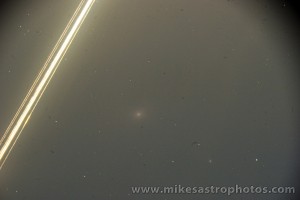
Jupiter with halo July 29, 2009
The stars tonight were bright. The moon set early and some rain came briefly through and then it was perfect. I haven’t seen it this dark in a long while. Since this meteor thing started I’ve only used my scope two times.
Tonight I was reworking the meteor trajectory taking into consideration data from the new video tape and I took a break to go outside. The sky was so dark I could see the Milky Way plain as day. I decided to take a few tripod shots and enjoy the night a little. The Milk Way shots didn’t quite work out but I got this one of Jupiter that is kind of cool. The halo around the planet is actually an optical anomaly caused I think by dew on my camera lens. Gives it an interesting effect.
As for the meteor, now that some analysis of the new tape has come in we believe we have located a new terminus for the meteor that is 1-2 miles north of the Safe Harbor dam. I have spoken to other meteorite hunters and reliable experts who believe there could be 40,000 grams of meteorite rock near the terminus point. Based on my picture and historical meteorite fall data several different experts believe there could be 3 10,000 gram rocks sitting in a corn field somewhere.

Quarryville July 28, 2009
Our NASA source analyzed the new video footage and told me he recalculated his trajectory based on the new data and his new terminus point is 20k west of his original location. We are working on a new strewn field map so that we can have a plan of attack this Saturday when we go out again. Prior to this new data the estimated strewn field was in Quarryville. When I was in Quarryville, I spoke to an Amish farmer who said his farm hand had witnessed the event and felt that it was so close he ducked down when it flew over. The boy claims to have seen the meteor crash into the ground. The boy’s location was 5 miles north of the Quarryville farm I was visiting. I haven’t calculated this account into my analysis yet, but with a quick eye up it looks possible.

Amish Tractor
I have reworked my line of site analysis of all locations and factored in the new Safe Harbor data. I believe my new trajectory and terminus point are better than they have ever been, its my best guess but it is still just a guess. I have some work to do on the meteor path before I publish it here, especially considering my last two guess were way wrong. With the new data and help I’m getting I’m feeling much better about this new projection. I have to do another lego shadow analysis before I can know for sure. I will post an updated map with meteor path and estimated terminus point tomorrow.
3 Comments for this entry
-
Welcome to Mike's Astro Photos!
Thanks for dropping by! Feel free to join the discussion by leaving comments, and if you want to stay updated bookmark the site, subscribe to the RSS feed, or like us on facebook.
If you think you've found a meteorite, want to go meteorite hunting have a question about astronomy, meteors, meteorites or just want to say hi, please send email to mike.hankey [AT] gmail.com
-
Mason Dixon Meteor Picture
Best Posts
Here are some of our best photos.
Quandrantids Fireball - 2011
Persied Fireballs - 2011
Lunar Eclipse - 2010
American Eagle - 2010

July 30th, 2009 on 10:30 am
Interesting – 20k west of quarryville would put the terminus point pretty much in the Susquehanna River
July 30th, 2009 on 1:02 pm
its close to the river, but the safe harbor video proves it made it past the river. terminus (burn-out point not crash site) should be 1-2 miles N/NE of the dam. The strewn field can then be calculated from there (further N/NE). Thanks!
July 30th, 2009 on 5:46 pm
Awesome pic