Tag: trajectory
Safe Harbor Update
by Mike Hankey, under Mason Dixon Meteor
I went out to the Safe Harbor Dam again today and met with the facilities manager. He didn’t want his name mentioned so we will just call him Bob. I picked up the video on DVD Saturday and Bob wasn’t there as he started his vacation that Friday. He emailed me today and said if I brought a thumb drive with me he could give me a better quality video. I met him at the dam at 6:00 PM and we talked about the video, where the cameras were and what he thought the meteor path would have been based on his knowledge of the plant and video. I was way off on my original observations and subsequent conclusions. When I first viewed the video and surveyed the site, I believed the cameras were in certain places when in reality they were in totally different places. So Bob helped me out big time understanding the layout of the dam and the path this meteor took when it passed by. He also came into the office while he was on his vacation and worked with me for over an hour. Thanks so much Bob!
Here is the video. I have edited the footage to include slow motion view, images of the site and the line of site and meteor path projections map. Watch the whole thing, the best images are at the end.
Important note about time in video (1:04:45): I talked to Bob about the clocks in his videos and asked if they were on time. He was adamant that the clocks were perfect time as this is required because they are a federal organization.
Here are the two full length un-edited videos. They are both about 1 minute long. Cam 1 event happens about halfway through. Cam 2 event happens in the beginning.
Cam 1 Full Length Highest Res Possible
Cam 2 Full Length Highest Res Possible
For easy reference here are some of the pictures used in the video:

Safe Harbor cam 1 top view

Safe Harbor cam 1 top side view

Camera 2 Line of Site View

Camera 2 opposing view
Click Picture Below For Bing Maps View

Safe Harbor camera line of site and estimated (best guess) meteor path
Check out Microsoft’s Bing for bird’s eye views of Safe Harbor. Bing Maps is so money. The satellite images are much higher quality and more current than any other earth software out there. Plus birds eye view is SICK!
Click Picture Below For Bing Maps birds eye view

A lot of other stuff has happened today. I have much to report from the field dealing with crazy angry people to pleasant helpful Amish farmers. I also have lots of news from the NASA source but I have to keep that under wraps for a little while still (sorry). Its late, I will post again tomorrow.
Field Report For Saturday July 25th 2009
by Mike Hankey, under Mason Dixon Meteor

Safe Harbor Water Power Corp July 25, 2009
Earlier last week I was reviewing the estimated meteor path on google earth and noticed the Safe Harbor Dam & power plant was very close to the current trajectory. I wrote the dam and asked them to review their security tapes from that night. They were nice enough to review and found two tapes that captured a light flare at 1:04:45 AM. The manager copied the tapes for me and I picked them up yesterday. After viewing the tapes on sight I surveyed the dam and camera locations.
I do not have permission to publish the videos yet, but if you are interested in seeing them you can email me and I can send you the files privately. The videos do not show the main body, but they do show an awful lot of light and some distinct moving shadows that can be tracked for about 4-5 frames.
After reviewing the videos and site I have currently made the following conclusions based on this new information:1) the meteor flew very close to the Safe Harbor Water Power Corp 2) the meteor flew most likely on the southern side of the plant. 3) The meteor made it across the Susquehanna. 4) The meteor was visible for 3 1/2-4 seconds.
I believe if the right people look at the video and examine the shadows on the ground they will be able to make some conclusions about the location of the meteor at that moment and the direction it was traveling. If you want to review the video please leave me a comment or send me an email.
While I was at the dam I met up with Mike O’Neil and John Stevenson, two graduate students from John’s Hopkins who are working on the meteor search as part of a project with the applied physics department. Mike and John were incredibly helpful in surveying the power plant as well as providing lots of analysis and insight into the event, the trajectory and possible crash site. Many thanks to Mike and John, I look forward to reading your reports.
")
John and me at York Water Company (39 55.227N 76 44.854W)
After the Safe Harbor survey we decided to go back to the location of the first video tape — York Water Company. None of us had personally been there yet. We had access to the data from that site and were under the belief that the meteor was on a eastern trajectory from that point, but we all wanted to see the site first hand so we could get a better idea about where this thing was going. I had the coordinates already so we plugged them into the GPS and headed over there. It took us a few minutes to locate the camera (its pretty sneaky). The camera is mounted under the silver electric box in the picture to the left, its the circle underneath. It took us a few minutes to figure that out but we had all remembered seeing that box posted in a previous picture and by looking at the site we eventually put two and two together.
John and Mike both work for a company that makes GPS devices and software so they are pretty knowledgeable about surveying sites and engineering in general. They explained to me the best way to determine the line of sight (LOS) and direction is to look for big objects on the ground and then find those objects in satalite photos like google earth or microsoft bing. Then use the NSEW directional markings in the satellite photo relative to the objects on the ground and not a compass, the sun or some other mechanism to evaluate the LOS direction.
")
York Water Company Camera Line Of Site (LOS)
As you can see in this picture, the camera is roughly parallel to the barbed wire security fence on the left. Prior to talking to John and Mike I was under the belief the meteor was traveling due east from the York County video (based on information from other sources) but was still having trouble accepting this, because I saw it in Freeland 20 miles south. This is what Mike wrote me today regarding the trajectory relative to York.

Possible meteor path across Safe Harbor
-
Welcome to Mike's Astro Photos!
Thanks for dropping by! Feel free to join the discussion by leaving comments, and if you want to stay updated bookmark the site, subscribe to the RSS feed, or like us on facebook.
If you think you've found a meteorite, want to go meteorite hunting have a question about astronomy, meteors, meteorites or just want to say hi, please send email to mike.hankey [AT] gmail.com
-
Mason Dixon Meteor Picture

Best Posts
Here are some of our best photos.
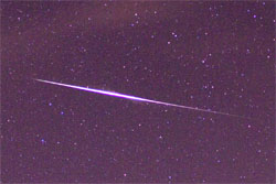
Quandrantids Fireball - 2011
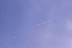
Persied Fireballs - 2011
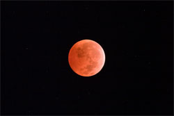
Lunar Eclipse - 2010

American Eagle - 2010