Mason Dixon Update – New Rob Matson Trajectory
by Mike Hankey, under Mason Dixon Meteor

Rob Matson Updated Search Area
I spent 6 weeks back in September and October regathering and re-calibrating all of the recorded evidence from the meteor fall. From the beginning Rob had told me the model he created was only as good as the input data used, minor flaws in the readings from the pictures could result in miles of distance on the ground. After extensive searching in the original drop zones proved unsuccessful I felt a burning desire to return to the original data, improve it and possibly obtain more.
There were two crucial pieces that had been missing from the original data set. The first was a useful reading from the York Water video. The fish eye lens and lack of reference stars in this video created a large margin of error. We were able to improve the York video by filming the full moon over two nights and overlaying the moons position with the meteor footage. After doing this we found more than 3 frames of meteor footage that lined up almost perfectly with the location of the moon — giving us a very strong reading from the York Video.
The second area we could improve on was the Alison Kruse fireball video. While it was a very good video to begin with, the only copy we had ever studied was the youtube version which was greatly distorted. I worked with Alison to obtain the raw video footage and this revealed two new stars in the image that helped us improve the altitude and azimuth readings from Alison’s video. During this time I was also able to recover 5 new videos from York, one of which had incredible shadows cast from a large building and a flag pole.

Trajectory V1 vs V2 Impact Points
After gathering, calibrating and reviewing all of the data I contacted Rob and asked him if he could improve his original model with the new data. He agreed, re-analyzed the new video footage and calibration photos and then recomputed the trajectory model. The data resulted in a shift of the end point of the trajectory line by 5 kilometers (3.2 miles). Now all things considered this is a very minor improvement considering the size of the Earth, but when you are on the ground walking around looking for tiny rocks this is a HUGE improvement. More importantly the new calibration data resulted in a shift of the previous altitude for my picture and thus the estimated terminal burst altitude from 10KM to 27KM. This new revelation would change the shape and location of the estimated strewnfield significantly.

12 Plotted Radar Returns - Suspected Terminal Burst
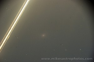
Lots of time by Rob and others was spent pouring over the NEXRAD radar data from that night, to date nothing obvious was visible. However Rob continued to research the radar data and was able to find 12 different returns from 4 different radar stations that plotted along the track. These returns registered 5-15 minutes after the fall and were all east of the ground track. Taking into consideration a 60km jet stream wind speed and time, Rob plotted all 12 of these returns back to a centralized spot along the track of the meteor. The radar returns Rob believes are left over dust from the terminal burst (when the meteor explodes) that had blown east in the minutes that followed the fall. The crazy thing is, all of these returns took place on the track right before the spot where my picture was taken. All along most people said my picture was an image of a bolide right after fragmentation (some people insist its a plane, despite all of the evidence against this theory). After realizing the radar find, Rob said “the radar data is the nail in the coffin on your picture actually being a bolide argument.”
Rob didn’t stop after improving the 3D track and finding over a dozen radar returns. He went on to gather the jet stream wind speeds from that night and also the surface wind speeds. Using the jet stream wind speeds he then calculated the dark flight for meteorites of various masses ranging from 10g to 10kg .
He ran the dark flight model using 35km, 30km and 25km altitudes. One of the most important keys to finding the location of the meteorites is knowing when the burst happened and when dark flight began. The computer models use the wind speeds and gravity calculations starting at this burst point. While the burst point we have now is not exact it is very close and substantiated by radar data, the york video and my picture.
The previous terminus point we had been using was at 10km altitude. This caused the estimated strewn field map to be narrow in the north south direction, but wider in the east west direction. This new discovery of a 30-35km burst point made a significant impact on the estimated strewn field map shifting the primary search location up to 10 miles! Instead of a small circular search area we now have a long narrow elliptical one (1 mile wide and 8 miles long).

PA Fireball - Strewnfield Estimate v2
How to track a fireball using Google Earth
Now while I was re-collecting the data and working with Rob to refine the trajectory I learned a lot about how to track a fireball. There is a 3D computational programmatic method based on trigonometry and aerospace engineering concepts (what Rob did using a Fortran program he wrote) and there is a ghetto fabulous, cocktail napkin plotting method that can be easily accomplished using Google Earth. Both of these methods require sets of values gathered from witnesses or recorded evidence. The values needed to compute the track of a fireball are:
- The longitude and latitude of the observer
- The altitude and azimuth of the meteor in the sky when first seen
- The altitude and azimuth of the meteor in the sky when last seen
Repeat for each observer. A Minimum of two observers is required.
I wanted to understand how the fireball was tracked but the computational method was way over my head. I tried figuring out the google method on my own for a while and then it all sort of clicked after a meteorite friend explained it to me in fairly simple terms. The method is as follows:
- For each observer (or photograph / video)
- Record the ALT/AZ for 2 points along the meteors path
- Mark point 1 and point 2 in a star chart that shows the ALT/AZ grid
- Draw a line through both points down to the horizon
- Record the AZ for the horizon position
- In Google Earth goto the observers lat / long
- Draw 3 lines starting at the observers location and out to infinity, use the google ruler tool to measure the angle degrees. Draw a line at the AZ angle for each of the 3 observations: point 1, point 2 & the horizon point
- The place where the horizon points intersect is the geometric impact point
- The places where different observers point 1 and point 2 intersect will be along the track
- Draw a line from the geometric impact point through the intersection points
Sounds pretty easy right!? Well after about 6 weeks of work I was able to do the above for: my telescopic bolide photo, the york meteor video, the kruse fireball video, the safe harbor shadow video, the york flag pole shadow video and the van meteor reflection video. This let me draw out an un-precise 2D track of the meteor. Guess what? The ghetto fabulous track I came up with mirrors Rob’s track with a 5% difference — they are almost the same. The image below shows all observers. The green line is observer point 1, the yellow line is observer point 2, the red line is the horizon point, the purple lines are AZ angles measured from the shadow videos.

Fireball Trajectory Analysis - All Observer Data
Now I know Robs track is more precise, it has wind blown dark flight estimates and it is scientifically computed. But working the track for myself was very rewarding and I now that I understand the math and logic behind the track and have computed very similar results myself, I know we are in the right area and feel good about searching there.
Due to a few weeks of snow and the holidays I have only gone hunting about 10 times since getting the new maps and coordinates. I have barely scratched the surface of the new area. Fortunately the winter is the best time to go meteorite hunting in this area. All of the crops are cut and there is very little vegetation on the ground. This spring the farmers will start planting crops again, which means more eyes will be on the ground and our chances of a local discovery will go up. It also means some fields will be plowed which will really hurt the possibilities of finding meteorites in those fields. After talking to several farmers we have until about May to have full access to mostly un-plowed fields. After that we will be limited to pastures, roads, commercial areas and parks. I know the odds of discovery are still very slim and I realize this, but at the same time I know the data we are using is the best it can possibly be. While I’m still in pursuit of finding more data regarding the fall I am very confident with the locations we are searching. The meteorites are on the ground, we know where they are, we just have to find them and even with the greatest data in the world, this is still very hard. Despite all of the fruitless effort that has gone into this and the time that has past, I am still blindly hopeful for a recovery. While I’m walking around fields I tell myself, that meteorite could be just one step away.
If you are interested in meteorite hunting in Lancaster County and you want to know where to search, email me (mike.hankey AT gmail.com) and I will send you the google earth KMZ file for this project.
1 Comment for this entry
-
Welcome to Mike's Astro Photos!
Thanks for dropping by! Feel free to join the discussion by leaving comments, and if you want to stay updated bookmark the site, subscribe to the RSS feed, or like us on facebook.
If you think you've found a meteorite, want to go meteorite hunting have a question about astronomy, meteors, meteorites or just want to say hi, please send email to mike.hankey [AT] gmail.com
-
Mason Dixon Meteor Picture
Best Posts
Here are some of our best photos.
Quandrantids Fireball - 2011
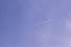
Persied Fireballs - 2011
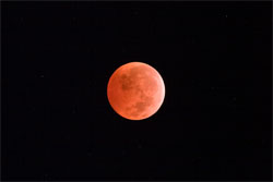
Lunar Eclipse - 2010
American Eagle - 2010

January 20th, 2010 on 9:57 am
Mike (and Rob),
Amazing stuff and worthy of an article in Meteorite Magazine. I believe there are space rocks out there in Amish country. It is nice to know the location prediction has firmed up with detailed data. I’ll be helping when I can and will be in touch with you soon. And yes, please send me the KMZ file.
John