Archive for 2010
Sombrero Galaxy 2009
by Mike Hankey, under Galaxies
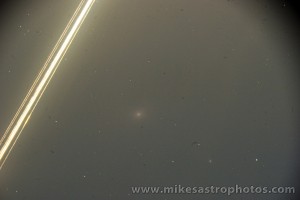
Here’s a recent shot of the Sombrero Galaxy from Dec 17th 2009. I’ve been wanting to shoot this guy again since getting my observatory setup but he hasn’t been available. I was up at 4:00 AM one night, ready to call it quits but saw the Sombrero on the goto menu. I extended the session an extra 15 minutes to capture 4×3 minute frames of this spectacular galaxy.

Sombrero Galaxy - December 17th, 2009
Sporadic Meteor – January 10th, 2009
by Mike Hankey, under Comets & Meteors
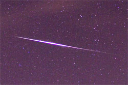
Here’s a sporadic meteor inside the constellation Canis Major (the dog). The bright star to the right is Sirius, the brightest star in the sky.

Sporadic Meteor - January 10th, 2010
Here’s the full picture:

Sporadic Meteor - January 10th, 2010
Lorton Meteorite – Estimated Strewnfield version 1
by Mike Hankey, under Comets & Meteors, Misc
Aerospace engineer and meteor scientist Rob Matson has taken a first crack at an estimated strewnfield for the Lorton meteorite. Since no video of the event has yet been released, Rob used multiple witness reports, radar data, the hammer stone location and wind speed information to plot the possible locations for other meteorites from this fall. Rob has stressed the importance of searching within a 1 mile radius of the Dr’s office first but has provided this additional information should those search areas become exhausted. One should not interpret these coordinates in an x-marks-the-spot type of way. They should serve more as a general guide to areas where different sized stones would be if they existed. The strategy Rob suggested was drawing a line between the dots and covering those areas, but only after exhausting the areas around the Dr’s office.
Here is a map of the coordinates plotted in Google Earth.

Lorton Meteorite - Estimated Strewnfield v1
Here is a copy of the Google Earth KMZ file for the Lorton Meteorite Estimated Strewnfield. You will need Google Earth installed on your computer in order to view this file.
Here are the raw data coordinates for the various masses:
Mass Longitude Latitude Dist (mi) Bearing
——- ——— ——– ——— ——-
3 g -77.12929 38.73888 5.2 59.3
5 g -77.14419 38.73268 4.3 58.7
15 g -77.16179 38.72688 3.2 56.0
40 g -77.18079 38.71908 2.1 52.6
120 g -77.19569 38.71088 1.1 50.6
(308 g) -77.21159 38.70068 -0- N/A
1150 g -77.22609 38.69048 1.1 228.0
3750 g -77.24249 38.67848 2.3 227.4
It looks like one of the points is on the driving range of the Fort Belvoir Golf Course. That would be a nice easy place to search if you had access.

Meteorite Hunting on Fort Belvoir Golf Course
There have been no new discoveries reported.
If you are a local resident in the Lorton area you are encouraged to be on the lookout for meteorites. Should you find one, please record the exact location where it was found and contact me at mike.hankey [AT] gmail.com
Lorton Virginia Meteorite – Update
by Mike Hankey, under Comets & Meteors

Lorton Dentist Office - Hammer Stone Site
On Wednesday night I watched the series premier of the new Meteorite Men TV show on the science channel. The show was fantastic and a must see! It airs Wednesday nights at 9:00 PM (and re-runs at 11:00 PM I think) on the science channel. Around 1:30 AM that night I was checking my emails before I went to bed and got an email from Steve Arnold, one of the costars of the show. The email read:
- What are you doing tomorrow? Want to go meteorite hunting?
My response was of course ‘heck ya’, but I had no idea what he was talking about. I thought to myself, am I dreaming? On the reply Steve filled me in on what had happened in Lorton. The funny thing is, Monday night at 6:00 PM I got a call from Mike Gaines (star witness of the Mason Dixon Meteor). Mike told me his daughter had just seen a huge fireball. At the time I said to myself, I can only handle one fireball right now and didn’t give it much thought. Turns out that meteorite knocked a whole in a Doctor’s Office just a few minutes earlier. The news didn’t hit the meteorite world until late Wednesday.

Steve Arnold - Lorton VA
I met up with Steve at the airport and then drove down to Lorton Virginia Thursday afternoon. Steve was pretty tied up with the media people and the TV production crew so I used the time to get some fresh hunting in at the spot. There had only been a couple of other meteorite hunters there before us so it was virgin territory right next to a confirmed fall. What else could you ask for? Well after a couple of days of hunting and turning up nada I can conclude hunting in a confirmed fall area is just as hard as hunting in Lancaster County. Despite the rain and freezing rain more hunters showed up Friday but to my knowledge no one has found any additional stones yet.
On the positive side, there are numerous witness reports of lots of fragmentation and multiple burning embers falling from the sky. This means there are a lot more rocks to be found. The area is densely populated and relatively easy searching terrain. There are lots of parking lots, public places, parks and walking paths. The exact trajectory is still unknown and to my knowledge no videos have yet been recovered. Finding video evidence of this fireball is critical to finding more meteorites on the ground. While we have an impact point, the orientation and relationship of this stone to the rest of the strewnfield is still unknown. I know Derek Bower and several other meteorite hunters will be hunting the area for the next few weeks. There is a very good chance more stones will be found soon. Personally I think I’m going to sit the rest of this one out. I can only handle one fireball at a time.
Here’s a map of the area and what is currently believed to be the primary search grounds.

Lorton VA Estimated Strewnfield Map - Hot zone
Even with a hammer stone the sad reality of meteorite hunting is the strewnfield could be up to 8 miles long or longer. In the case of Lorton, because we have no video we don’t know the trajectory of the meteor and therefore can not guess the elongated strewnfield with any degree of certainty, a second stone or recovery of video tape is critical to finding the rest of this meteor.
Here’s a hypothetical take on what the larger strewnfield could look like if it was 8 miles long based on our current knowledge of the trajectory. As you can see the search angle could be anywhere from 45º-70º NE of the original impact site. It is possible larger stones (if they exist) would have traveled SW of the impact site. From a hunting standpoint though the odds are better if you are looking for smaller stones (because there are more of them). The smaller meteorites would be NE of the impact site.

Lorton Elongated Estimated Strewnfield
Here are a few articles about the meteor:
- Baltimore Sun – Featuring Yours Truly
- Washington Post
- Frank Roylance’s Baltimore Weather – Over 100 fascinating eye witness accounts
I will keep you posted on any further developments on this meteorite story.
Lorton Virginia Meteorite
by Mike Hankey, under Misc
On Monday January 18th at approximately 5:40 PM a huge fireball streaked the skies above PA, MD and VA. A piece of it ripped a hole through the roof of a Dentist’s office (this is called a hammer stone). Witness reports indicate fragmentation and numerous illuminated timbers falling to the ground. There are definitely more stones to be found and we’ve got a really good idea where they are. Meteorite hunting really doesn’t get better than this.
Mason Dixon Update – New Rob Matson Trajectory
by Mike Hankey, under Mason Dixon Meteor

Rob Matson Updated Search Area
I spent 6 weeks back in September and October regathering and re-calibrating all of the recorded evidence from the meteor fall. From the beginning Rob had told me the model he created was only as good as the input data used, minor flaws in the readings from the pictures could result in miles of distance on the ground. After extensive searching in the original drop zones proved unsuccessful I felt a burning desire to return to the original data, improve it and possibly obtain more.
There were two crucial pieces that had been missing from the original data set. The first was a useful reading from the York Water video. The fish eye lens and lack of reference stars in this video created a large margin of error. We were able to improve the York video by filming the full moon over two nights and overlaying the moons position with the meteor footage. After doing this we found more than 3 frames of meteor footage that lined up almost perfectly with the location of the moon — giving us a very strong reading from the York Video.
The second area we could improve on was the Alison Kruse fireball video. While it was a very good video to begin with, the only copy we had ever studied was the youtube version which was greatly distorted. I worked with Alison to obtain the raw video footage and this revealed two new stars in the image that helped us improve the altitude and azimuth readings from Alison’s video. During this time I was also able to recover 5 new videos from York, one of which had incredible shadows cast from a large building and a flag pole.

Trajectory V1 vs V2 Impact Points
After gathering, calibrating and reviewing all of the data I contacted Rob and asked him if he could improve his original model with the new data. He agreed, re-analyzed the new video footage and calibration photos and then recomputed the trajectory model. The data resulted in a shift of the end point of the trajectory line by 5 kilometers (3.2 miles). Now all things considered this is a very minor improvement considering the size of the Earth, but when you are on the ground walking around looking for tiny rocks this is a HUGE improvement. More importantly the new calibration data resulted in a shift of the previous altitude for my picture and thus the estimated terminal burst altitude from 10KM to 27KM. This new revelation would change the shape and location of the estimated strewnfield significantly.

12 Plotted Radar Returns - Suspected Terminal Burst
Lots of time by Rob and others was spent pouring over the NEXRAD radar data from that night, to date nothing obvious was visible. However Rob continued to research the radar data and was able to find 12 different returns from 4 different radar stations that plotted along the track. These returns registered 5-15 minutes after the fall and were all east of the ground track. Taking into consideration a 60km jet stream wind speed and time, Rob plotted all 12 of these returns back to a centralized spot along the track of the meteor. The radar returns Rob believes are left over dust from the terminal burst (when the meteor explodes) that had blown east in the minutes that followed the fall. The crazy thing is, all of these returns took place on the track right before the spot where my picture was taken. All along most people said my picture was an image of a bolide right after fragmentation (some people insist its a plane, despite all of the evidence against this theory). After realizing the radar find, Rob said “the radar data is the nail in the coffin on your picture actually being a bolide argument.”
Rob didn’t stop after improving the 3D track and finding over a dozen radar returns. He went on to gather the jet stream wind speeds from that night and also the surface wind speeds. Using the jet stream wind speeds he then calculated the dark flight for meteorites of various masses ranging from 10g to 10kg .
He ran the dark flight model using 35km, 30km and 25km altitudes. One of the most important keys to finding the location of the meteorites is knowing when the burst happened and when dark flight began. The computer models use the wind speeds and gravity calculations starting at this burst point. While the burst point we have now is not exact it is very close and substantiated by radar data, the york video and my picture.
The previous terminus point we had been using was at 10km altitude. This caused the estimated strewn field map to be narrow in the north south direction, but wider in the east west direction. This new discovery of a 30-35km burst point made a significant impact on the estimated strewn field map shifting the primary search location up to 10 miles! Instead of a small circular search area we now have a long narrow elliptical one (1 mile wide and 8 miles long).

PA Fireball - Strewnfield Estimate v2
How to track a fireball using Google Earth
Now while I was re-collecting the data and working with Rob to refine the trajectory I learned a lot about how to track a fireball. There is a 3D computational programmatic method based on trigonometry and aerospace engineering concepts (what Rob did using a Fortran program he wrote) and there is a ghetto fabulous, cocktail napkin plotting method that can be easily accomplished using Google Earth. Both of these methods require sets of values gathered from witnesses or recorded evidence. The values needed to compute the track of a fireball are:
- The longitude and latitude of the observer
- The altitude and azimuth of the meteor in the sky when first seen
- The altitude and azimuth of the meteor in the sky when last seen
Repeat for each observer. A Minimum of two observers is required.
I wanted to understand how the fireball was tracked but the computational method was way over my head. I tried figuring out the google method on my own for a while and then it all sort of clicked after a meteorite friend explained it to me in fairly simple terms. The method is as follows:
- For each observer (or photograph / video)
- Record the ALT/AZ for 2 points along the meteors path
- Mark point 1 and point 2 in a star chart that shows the ALT/AZ grid
- Draw a line through both points down to the horizon
- Record the AZ for the horizon position
- In Google Earth goto the observers lat / long
- Draw 3 lines starting at the observers location and out to infinity, use the google ruler tool to measure the angle degrees. Draw a line at the AZ angle for each of the 3 observations: point 1, point 2 & the horizon point
- The place where the horizon points intersect is the geometric impact point
- The places where different observers point 1 and point 2 intersect will be along the track
- Draw a line from the geometric impact point through the intersection points
Sounds pretty easy right!? Well after about 6 weeks of work I was able to do the above for: my telescopic bolide photo, the york meteor video, the kruse fireball video, the safe harbor shadow video, the york flag pole shadow video and the van meteor reflection video. This let me draw out an un-precise 2D track of the meteor. Guess what? The ghetto fabulous track I came up with mirrors Rob’s track with a 5% difference — they are almost the same. The image below shows all observers. The green line is observer point 1, the yellow line is observer point 2, the red line is the horizon point, the purple lines are AZ angles measured from the shadow videos.

Fireball Trajectory Analysis - All Observer Data
Now I know Robs track is more precise, it has wind blown dark flight estimates and it is scientifically computed. But working the track for myself was very rewarding and I now that I understand the math and logic behind the track and have computed very similar results myself, I know we are in the right area and feel good about searching there.
Due to a few weeks of snow and the holidays I have only gone hunting about 10 times since getting the new maps and coordinates. I have barely scratched the surface of the new area. Fortunately the winter is the best time to go meteorite hunting in this area. All of the crops are cut and there is very little vegetation on the ground. This spring the farmers will start planting crops again, which means more eyes will be on the ground and our chances of a local discovery will go up. It also means some fields will be plowed which will really hurt the possibilities of finding meteorites in those fields. After talking to several farmers we have until about May to have full access to mostly un-plowed fields. After that we will be limited to pastures, roads, commercial areas and parks. I know the odds of discovery are still very slim and I realize this, but at the same time I know the data we are using is the best it can possibly be. While I’m still in pursuit of finding more data regarding the fall I am very confident with the locations we are searching. The meteorites are on the ground, we know where they are, we just have to find them and even with the greatest data in the world, this is still very hard. Despite all of the fruitless effort that has gone into this and the time that has past, I am still blindly hopeful for a recovery. While I’m walking around fields I tell myself, that meteorite could be just one step away.
If you are interested in meteorite hunting in Lancaster County and you want to know where to search, email me (mike.hankey AT gmail.com) and I will send you the google earth KMZ file for this project.
M37 Jan 8, 2010
by Mike Hankey, under Stars
Here’s a shot of the open star cluster M37 from January 8th, 2010.

Messier 37 - January 8th, 2009
M101 – Pin Wheel Galaxy
by Mike Hankey, under Galaxies
Here’s a picture of M101, the famous Pin Wheel Galaxy. This image is a 45 minute exposure containing 9×5 minute sub frames @ ISO800 stacked with DSS.

M101 Pin Wheel Galaxy - January 9th, 2010
Andromeda Galaxy – M31
by Mike Hankey, under Galaxies
I’ve been wanting to shoot a good picture of the Andromeda Galaxy since I got my telescope. Andromeda is the closest galaxy to the Milky Way and a very large target. Its proportionally a little larger than the full moon in the sky (no you can’t really see it with your naked eye, but if you could it would be as big as the moon). Andromeda is a hard target for larger scopes because of its size. Here’s the best picture of Andromeda I’ve been able to do yet. Its a total of 90×2 minute frames (180 minutes!) and it still doesn’t look the way I would expect it to.

Andromeda Galaxy - November 28th, 2009
NGC 2244
by Mike Hankey, under Nebula
Here is a photo of NGC 2244 an open cluster within the Rosetta Nebula discovered by John Flamsteed in 1690. The Rosetta Nebula is a giant molecular cloud and the stars inside this cluster were formed from the nebula’s matter. You can see bits of the nebula cloud in the picture below.

NGC 2244 - December 23rd, 2009
Flock Of Geese
by Mike Hankey, under Misc
Here’s a flock of geese that flew near my house on December 20th, 2009. They were headed on a north western trajectory. If I were them I’d be headed south, but then again I heard it was 30 degrees in Miami yesterday, so who knows.

Flock of Geese - December 20th, 2009
Satellite Photos During Geminids
by Mike Hankey, under Misc
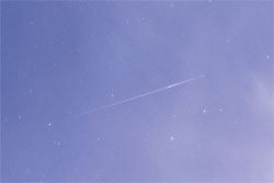
During the Geminid meteor shower I took over 1,000 photos. When reviewing the pictures you basically have to step through each pic looking for meteors. As you skip through pictures you see the stars move and sometimes you will see something that wasn’t there before. I noticed something over a series of 40 pictures at 30 seconds each, a total of 20 minutes. I thought it was a satellite a first, but after review I noticed it stayed in the field of view for 20 minutes but most of the satellites I’ve photographed before only lasted for 30 seconds or less. So I guessed this was probably a slow moving high orbit satellite. I thought it would have been cool if this was a comet or an asteroid or an alien UFO, but I asked around and my initial suspicions were confirmed. This is most likely a HEO satellites (HEO=Highly Elliptical Orbit: aka ‘Molniya’ orbits) or a geosynchronous satellite. I’m still working on an official ID. It would be nice if one of these times I would catch an actual alien mothership.

Satellite Astrophoto

Satellite Astrophoto

Satellite Astrophoto
Here is the full photo of the picture. Can you see the satellite streak? (hint: lower left, to the left of Sirius).

Satellite Astrophoto - Can you find it?
UPDATE: Jan 5th, 2009:
Marco Langbroek from SatCamTracking was able to identify this satellite as a Russian GLONASS navigation satellite. Here’s what Marco had to say:
It is Kosmos 1948 (88-043C), a Russian GLONASS navigation satellite launched in 1988. GLONASS is the Russian equivalent of the American GPS. They move in orbits with a revolution period of two revolutions/day, at roughly 19000 km altitude (that’s some 12000 miles).
Flame Nebula
by Mike Hankey, under Nebula
Here’s an astrophoto of the Flame Nebula, an emission nebula in the Constellation Orion. The bright star in the lower right is Alnitak, the eastern most star in Orion’s belt. The flame nebula is part of a vast network of nebulas that cover Orion and it is located just above the Horse Head Nebula. This picture represents 15×5 minute exposures for a total exposure time of 75 minutes.

Flame Nebula - December 20th, 2009
-
Welcome to Mike's Astro Photos!
Thanks for dropping by! Feel free to join the discussion by leaving comments, and if you want to stay updated bookmark the site, subscribe to the RSS feed, or like us on facebook.
If you think you've found a meteorite, want to go meteorite hunting have a question about astronomy, meteors, meteorites or just want to say hi, please send email to mike.hankey [AT] gmail.com
-
Mason Dixon Meteor Picture
Best Posts
Here are some of our best photos.
Quandrantids Fireball - 2011
Persied Fireballs - 2011
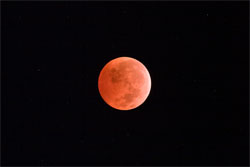
Lunar Eclipse - 2010
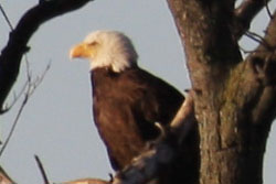
American Eagle - 2010